
Pole Locations and Surveyed Trees
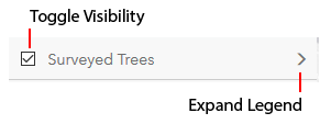
Users may use the “plus” (+) button on the map to zoom in and the "minus" (-) button to zoom out. Use the check boxes in the legend to toggle layer visibility on and off, and the expand arrows (>) to expand that layer's legend. BY clicking any tree on the map, you can see view the data associated with it.
Sources:
PSE (Puget Sound Energy). 2017. GIS, CAD, and static map data provided to Environmental Science Associates (ESA), Seattle, WA, by PSE, Bellevue, WA. Included files titled North_8-3-17.dxf and South_8-3-17.dxf (sent on August 3, 2017), geodatabase titled AccessRoutes_StringSite (sent on August 11, 2017), and file titled energize eastside non-variance (4-1 to RIC)_plan strs only_rev p (sent on December 27, 2017).
The Watershed Company. 2017. GIS Dataset Labeled as 2017-12-15 Data for EIS Consultant. December 15, 2017.