
Phase 2 Draft EIS
What is the Phase 2 Draft EIS?
The Phase 2 Draft EIS is the second of a two-phase Draft EIS process being used to evaluate the potential for significant environmental impacts of PSE’s proposed Energize Eastside project –a new electrical transmission line and substation. The Phase 1 Draft EIS was a programmatic analysis. It broadly evaluated the general impacts associated with feasible and reasonable options available to address PSE’s identified objectives for the project.
The Phase 2 Draft EIS is a project-level evaluation. It includes details of the proposed development at specified geographic locations with detailed analysis of potential environmental impacts. The Phase 2 Draft EIS is informed by the programmatic-level evaluations conducted during Phase 1 and by public comments submitted on the Phase 1 Draft EIS and during Phase 2 Scoping. A Final EIS will be issued after completion of the Phase 2 Draft EIS.
Elements of the Environment Analyzed in the EIS
The Phase 2 Draft EIS considers potential impacts on the natural environment and the built environment, including the following resource topics:
Impacts are analyzed both in the short-term (during construction) and over the long-term operation of the project. In compliance with SEPA, the EIS also addresses cumulative impacts and significant unavoidable adverse impacts.
The Phase 2 Draft EIS considers potential impacts on the natural environment and the built environment, including the following resource topics:
- Land Use & Housing
- Scenic Views & the Aesthetic Environment
- Water Resources
- Plants & Animals
- Greenhouse Gases
- Recreation
- Historic & Cultural Resources
- Environmental Health - Electric & Magnetic Fields
- Environmental Health - Pipeline Safety
- Economics
Impacts are analyzed both in the short-term (during construction) and over the long-term operation of the project. In compliance with SEPA, the EIS also addresses cumulative impacts and significant unavoidable adverse impacts.
What Stage of Design Does the Phase 2 Draft EIS Evaluate?
Consistent with SEPA, the Phase 2 Draft EIS was prepared at an early stage of design for PSE’s project. This allows agency review and input early in the process, affording an opportunity to identify potential issues or problems. Information about the project is subject to refinement as the design is further developed. In cases of uncertainty about potential impacts, the Phase 2 Draft EIS uses a “worst-case” analysis to ensure that potentially significant impacts are addressed.
Consistent with SEPA, the Phase 2 Draft EIS was prepared at an early stage of design for PSE’s project. This allows agency review and input early in the process, affording an opportunity to identify potential issues or problems. Information about the project is subject to refinement as the design is further developed. In cases of uncertainty about potential impacts, the Phase 2 Draft EIS uses a “worst-case” analysis to ensure that potentially significant impacts are addressed.
Download the Phase 2 Draft EIS
The Phase 2 Draft EIS files are available below. The consolidated Phase 2 Draft EIS documents are larges file which may take a few moments to download. Smaller sections of the document are also available below for download.
The Phase 2 Draft EIS files are available below. The consolidated Phase 2 Draft EIS documents are larges file which may take a few moments to download. Smaller sections of the document are also available below for download.
Consolidated Phase 2 Draft EIS and Appendices Files
Note: These are large files and may take a moment to download.
Energize Eastside Phase 2 Draft EIS Volume 1 - Draft EIS
Energize Eastside Phase 2 Draft EIS Volume 2 - Appendices
Individual Phase 2 Draft EIS Files
Cover, Table of Contents, Fact Sheet
Chapter 1 Introduction and Summary
Chapter 2 Project Alternatives
Chapter 3 Long-term (Operation) Impacts and Potential Mitigation (Note: Individual sections of Chapter 3 are provided below.)
Chapter 5 Cumulative Impacts
Chapter 6 Significant Unavoidable Adverse Impacts
Chapter 7 Errata
Chapter 8 References (Note: Please contact [email protected] if you are unable to access sources cited in the Phase 2 Draft EIS.)
Chapter 9 Distribution List
Chapter 10 Acronyms and Glossary
Appendix A General Construction and Access Description
Appendix B Supplemental Information: Land Use
Appendix C Scenic Views and Aesthetic Environment Methodology
Appendix E PSE Vegetation Management Standards
Appendix F Recreation Policies
Appendix G Supplemental Information: Historic Resources
Appendix H Supplemental Information: EMF (Unique Uses in the Study Area)
Appendix I Supplemental Information: Pipeline Safety
Interactive Maps
You can access interactive maps that show water resources, parks and recreation facilities and trees potentially impacted by the action alternatives, as well as existing and proposed pole locations, by clicking on the links provided below. The first two maps are similar to the maps included in the Phase 2 Draft EIS, Section 3.3.5 (Water Resources) and Section 3.6.5 (Recreation). The three maps give you the ability to zoom in to locations along the project corridor and to select key features. Use your mouse to click on a segment or recreation facility to bring up a pop-up window that provides additional information.
Water Resources Interactive Map
Recreation Interactive Map
Pole and Tree Locations Interactive Map
Note: These are large files and may take a moment to download.
Energize Eastside Phase 2 Draft EIS Volume 1 - Draft EIS
Energize Eastside Phase 2 Draft EIS Volume 2 - Appendices
Individual Phase 2 Draft EIS Files
Cover, Table of Contents, Fact Sheet
Chapter 1 Introduction and Summary
Chapter 2 Project Alternatives
Chapter 3 Long-term (Operation) Impacts and Potential Mitigation (Note: Individual sections of Chapter 3 are provided below.)
- Section 3.1 Land Use and Housing
- Section 3.2 Scenic Views and the Aesthetic Environment
- Section 3.3 Water Resources
- Section 3.4 Plants and Animals
- Section 3.5 Greenhouse Gases
- Section 3.6 Recreation
- Section 3.7 Historic and Cultural Resources
- Section 3.8 Environmental Health – Electric and Magnetic Fields
- Section 3.9 Environmental Health – Pipeline Safety
- Section 3.10 Economics
Chapter 5 Cumulative Impacts
Chapter 6 Significant Unavoidable Adverse Impacts
Chapter 7 Errata
Chapter 8 References (Note: Please contact [email protected] if you are unable to access sources cited in the Phase 2 Draft EIS.)
Chapter 9 Distribution List
Chapter 10 Acronyms and Glossary
Appendix A General Construction and Access Description
Appendix B Supplemental Information: Land Use
Appendix C Scenic Views and Aesthetic Environment Methodology
- Appendix C Attachment 1 – Diameter of Existing and Proposed Wire
- Appendix C Attachment 2 – Methodology and Visual Simulations (Note: This is a large file and may take a moment to download.)
Appendix E PSE Vegetation Management Standards
Appendix F Recreation Policies
Appendix G Supplemental Information: Historic Resources
Appendix H Supplemental Information: EMF (Unique Uses in the Study Area)
Appendix I Supplemental Information: Pipeline Safety
Interactive Maps
You can access interactive maps that show water resources, parks and recreation facilities and trees potentially impacted by the action alternatives, as well as existing and proposed pole locations, by clicking on the links provided below. The first two maps are similar to the maps included in the Phase 2 Draft EIS, Section 3.3.5 (Water Resources) and Section 3.6.5 (Recreation). The three maps give you the ability to zoom in to locations along the project corridor and to select key features. Use your mouse to click on a segment or recreation facility to bring up a pop-up window that provides additional information.
Water Resources Interactive Map
Recreation Interactive Map
Pole and Tree Locations Interactive Map
Alternatives Studied in the Phase 2 Draft EIS
Descriptions of the alternatives analyzed in the Phase 2 Draft EIS are provided below.
Descriptions of the alternatives analyzed in the Phase 2 Draft EIS are provided below.
No Action
This alternative is required under SEPA as a baseline against which the action alternatives can be compared. Under this alternative, maintenance, conservation, and certain other activities that do not require state or local government approvals could continue. No new 230 kV line or substation would be built.
This alternative is required under SEPA as a baseline against which the action alternatives can be compared. Under this alternative, maintenance, conservation, and certain other activities that do not require state or local government approvals could continue. No new 230 kV line or substation would be built.
|
Action Alternatives (PSE's Proposal and Alternatives)
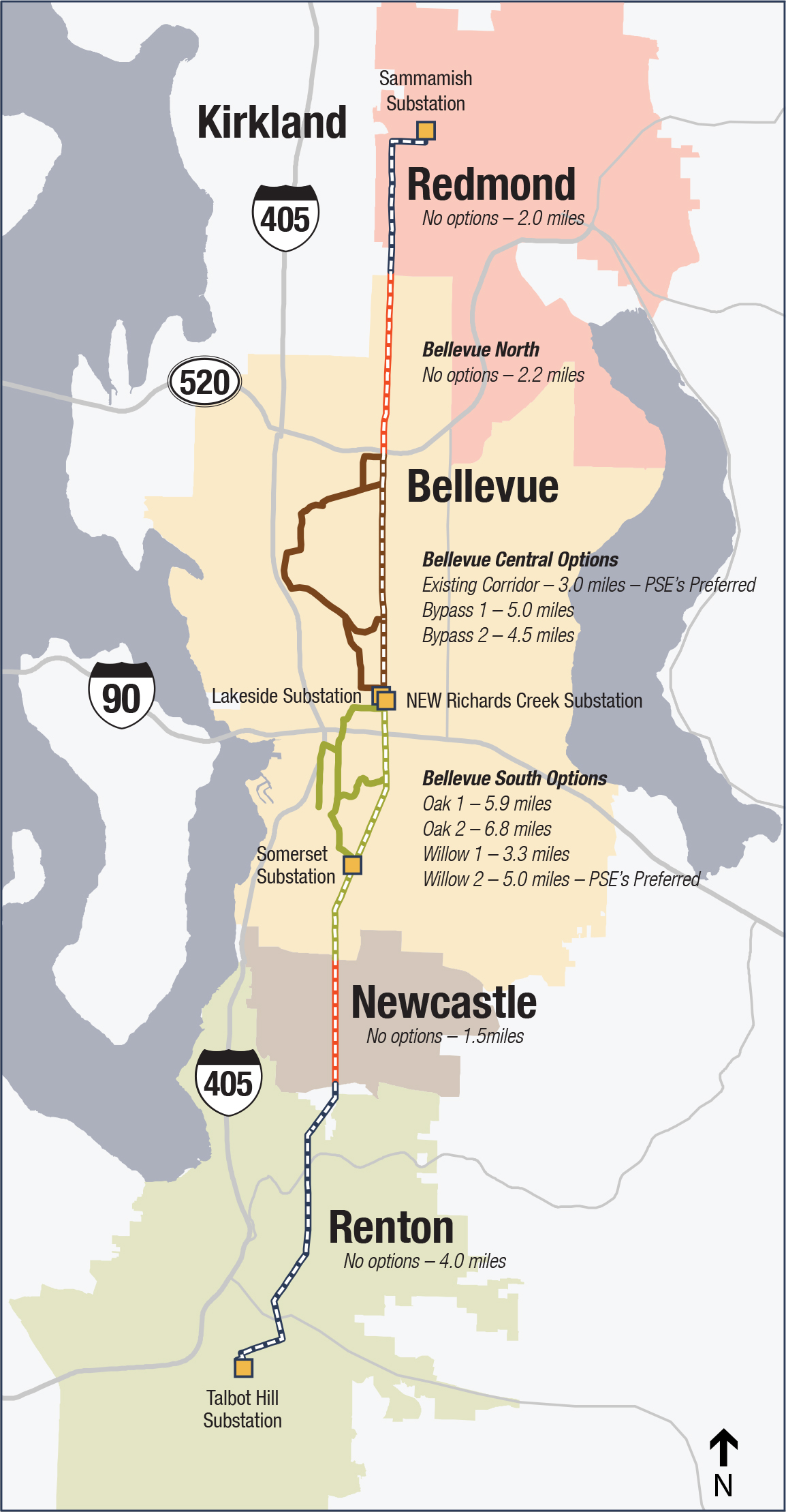
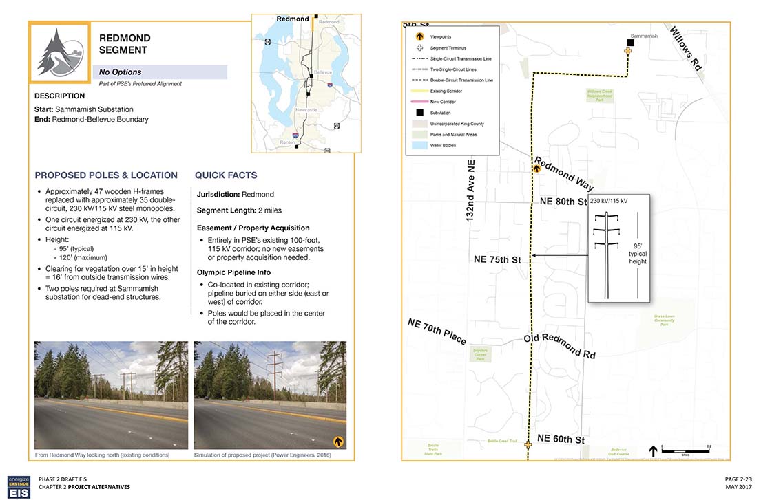
PSE has proposed to route a new 230 kV transmission line, to the extent feasible, within PSE’s existing Sammamish-Lakeside-Talbot Hill 115 kV transmission line corridor. At the existing Lakeside distribution substation a new substation (Richards Creek) would be developed on the vacant parcels to the south to accommodate a new 230 kV transformer and associated electrical equipment. For the Phase 2 Draft EIS, the proposed transmission line corridor is divided into six segments (Redmond, Bellevue North, Bellevue Central, Bellevue South, Newcastle, and Renton segments) with alternative alignments applying to two segments (Bellevue Central and Bellevue South segments). PSE has proposed three alternative alignments for the Bellevue Central segment and four alternative alignments for the Bellevue South segment. PSE has not identified alternative alignments for the other four segments. The Alignment Map on this webpage shows the six segments and alternative alignments. Click on the map to view it in larger size. Segment Descriptions
To view descriptions and maps of the six segments and alternative alignments, click on the thumbnails below. |
Alignment Map
|
Redmond Segment
Bellevue North Segment 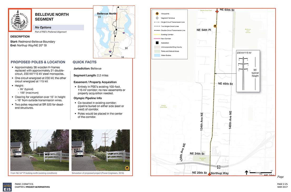
Bellevue Central Segment - Existing Corridor Option 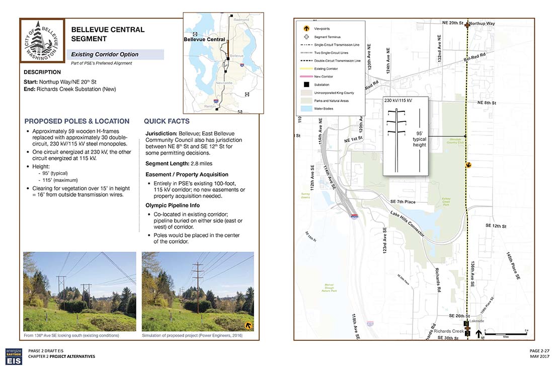
Bellevue Central Segment - Bypass Option 1 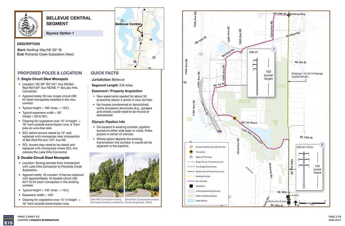
Bellevue Central Segment - Bypass Option 2 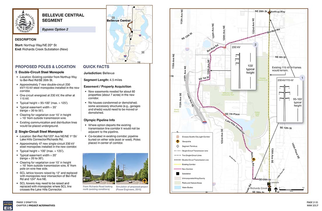
Bellevue South Segment - Oak 1 Option 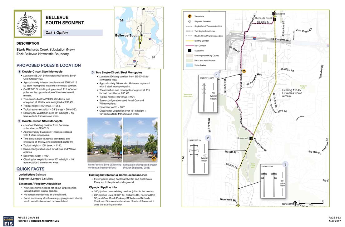
Bellevue South Segment - Oak 2 Option 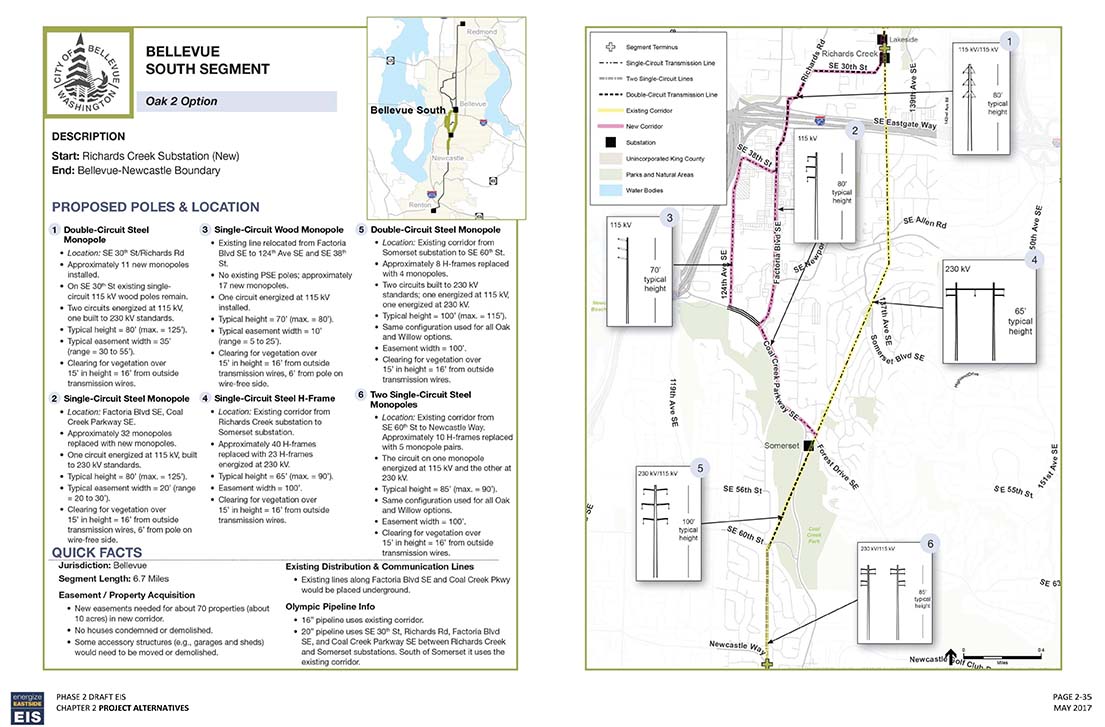
Bellevue South Segment - Willow 1 Option 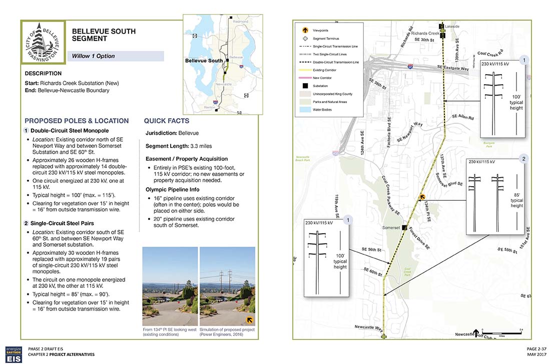
Bellevue South Segment - Willow 2 Option 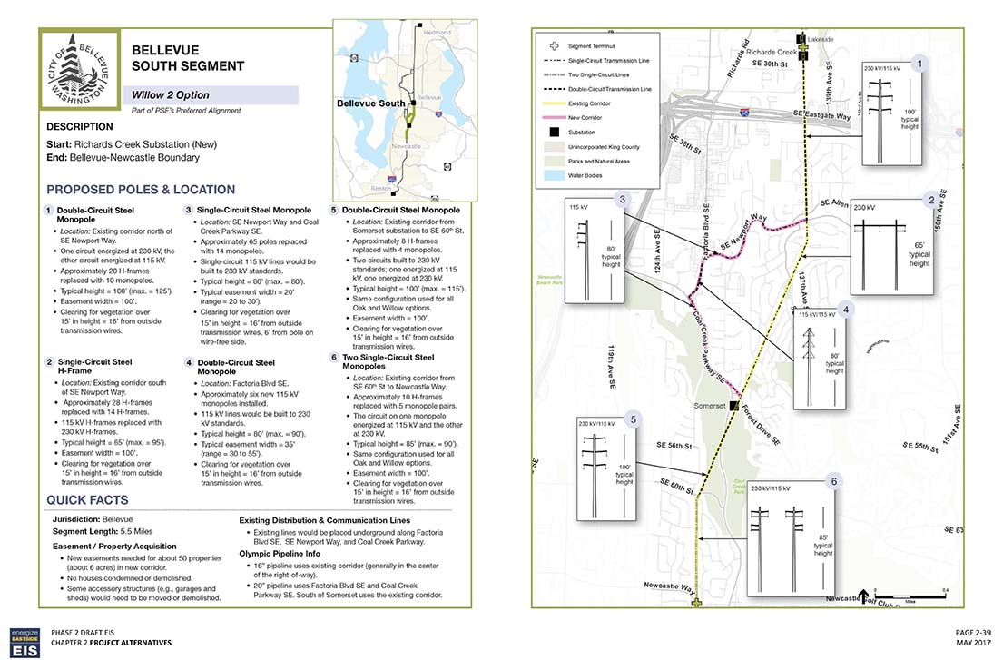
Newcastle Segment 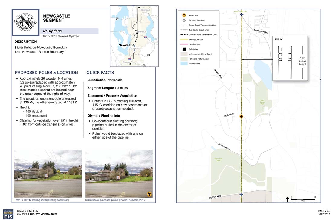
Renton Segment 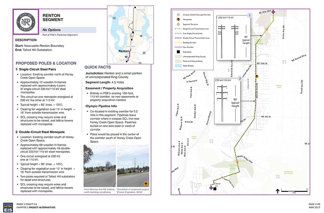
|